El Carmen
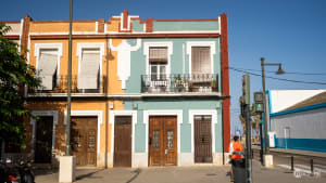
With its narrow cobblestone streets and mediaeval remains, El Carmen is the historical centre of Valencia. Its old houses are painted in the bright colours of urban art, and its streets are buzzing with people, small cafes, artisanal shops, tapas bars, and live-music venues.
El Carmen in a nutshell...
The northwestern section of Valencia’s Old Town where medieval history meets vibrant city life.
Historical highlights: Home to remnants of 11th-century Moorish walls, the Gothic Torres de Quart and Torres de Serranos city gates, and Portal Valldigna (gateway to the former Moorish quarter).
Cultural attractions: Houses the IVAM (modern art museum), Centre del Carme (contemporary culture center in a 13th-century monastery), and numerous colorful street art murals that transform building facades throughout the neighborhood.
Atmosphere: Narrow cobblestone streets, charming plazas that transform from quiet cafés by day to bustling nightlife spots after dark, artisanal shops, and bohemian energy make this area perfect for wandering and discovery on foot.
Barrio del Carmen is the northwestern section of the Ciutat Vella, Valencia’s Old Town district. Out of the six neighbourhoods in the district, El Carmen is the most evidently mediaeval area, a must-see for anyone interested in sightseeing. But it is also an extremely vibrant place, where history lives side by side with the people.

El Carmen’s narrow cobblestone streets are populated by old houses with iron balconies, small cafes, artisanal businesses, tapas bars, and live-music venues. The neighbourhood is also home to colourful street art and graffiti, along with the historical remains and museums devoted to preserving and disseminating Valencian history, culture, and art.
This is the bohemian area of Valencia, rich in urban art, historical sites, alternative shops, and outdoor terraces. This is a place to get lost and wander around, a place to discover little by little. Here, art is in the streets.
The barrio is filled with the chatter of people - both visitors and locals - the smell of orange blossoms and local food, the bright colours of the graffiti and painted houses, the earthy tones of the mediaeval stones.

Walking the streets of El Carmen you’ll be charmed by its tranquil and joyful energy, you’ll learn about Valencia’s history, its people, and their way of life. While crossing the neighbourhood at its widest points only takes a little over 10 minutes, this cobbled labyrinth has thousands of years of history to offer. El Carmen is the lived and living history of Valencia.
Brief History
Barrio del Carmen developed in the area around the current Plaza del Carmen, between the Muslim and the Christian walls of the city.
Here you have the details regarding the various historical stages of this neighbourhood, from its origins in the Roman era until the present day.
Foundation and Development (138 BC-800 AD)
Valencia (then Valentia) was founded by Roman settlers on the bank of the Turia river. The centre of the city was roughly in the area currently occupied by Plaza de la Virgen and the Cathedral.
After the fall of Roman Valencia, the city saw the arrival of various Germanic populations, among which were the Visigoths.
Beginning of Moorish Rule (711)
Valencia was peacefully conquered by the Muslim rulers and the city became part of the Caliphate of Damascus, and later on part of the Caliphate of Cordoba.
Establishment of the Taifa de Balansiya (1010)
An independent Moorish Kingdom of Valencia was established. This would become an era of splendour and development for the city. An orchard was established in what is now El Carmen.
Muslim City Walls (1021-1061)
Most of the city’s fortified perimeter dating back to the Muslim era was built in this period, still under the Taifa.
Morería (1238)
After the Christians conquered the city in 1238, the Muslim population that decided to stay in Valencia was confined to the eastern section of the current Carmen neighbourhood. This area would continue to exist until 1609, with the expulsion of the Moriscos from Spain.
Carmelites (1281)
The religious order of the Carmelites established themselves in Valencia and built the Convento del Carmen, which would later give its name to the whole neighbourhood.
Brothel (1325)
El Carmen became Europe’s biggest and most notorious brothel. The western part of today’s Carmen was occupied until 1671 by hostels where prostitution was practised. Reportedly, it was a highly regulated, controlled, and well-kept area.
Christian City Walls (1356-1370)
A new set of walls was built by the Christian kings, surrounding and enclosing the Muslim walls. The northern edge of this new walled enclosure, between the Christian and the Muslim walls, developed as the Carmen neighbourhood at this time.
El Carmen (Present Day)
The neighbourhood is today officially recognised as such, and it is one of the most vibrant parts of the city, a place for atmospheric bars, history, and art.
Mediaeval Remains
The majority of the urban and demographic development of the middle ages took place in what we know today as the Ciutat Vella, the historical centre of Valencia.

In particular, the Carmen neighbourhood passes on the memory of these ages of splendour, the Valencian Golden Age (14th and 15th centuries) and the Taifa of Valencia (independent Moorish kingdom of Valencia between 1010 and 1238).
Muralla Arabe
From the beginning of its days until today, Valencia has known three different sets of city walls: Roman, Moorish and Christian. We only have remains of the last two walls, and the remains of the Muralla Arabe (meaning Arab Walls in English) can be found in the Carmen neighbourhood.

Under Muslim rule (711-1238), a fortified perimeter of the city was built. Most of the remains we have nowadays were constructed between 1021 and 1061. Unfortunately, the condition of these few remains is not ideal. They can only give us a glimpse of the splendour of Valencia’s Muslim past and its walled enclosure.
Here is a list of where you can find these remains, often integrated into houses or local businesses.
Carrer d’en Borràs
Here you’ll find a semicircular tower (Torre del Ángel), today converted into a house, which originally formed part of the 11th-century wall. Next to the towers remains a piece of the ancient wall itself.

Calle de Salinas
The remains found here are particularly exposed and battered by time, but you’ll still be able to appreciate the 2-metre thick (6.5 feet) masonry wall.

Calle Blanqueria
Inside a private building on this street is a perfectly restored remnant of the old Muslim walls, which separated the city from the river. A group of battlements that crowned the wall are still preserved, while a semicircular tower can be found on the inside.
Calle Roteros
At the intersection with Calle Palomino, you can find a piece of the ancient wall inside a local bakery, the Horno Montaner.

Galeria del Tossal
Inside this underground art gallery you can find a 20-metre long (almost 66 feet) section of the wall and a square tower. The gallery is located in Plaza del Tossal, which stands at the edge between the Carmen and the Mercat neighbourhoods.

Torres de Quart
The Torres de Quart (Quart towers), built between 1443 and 1469, are an example of Gothic military construction in Valencia. These towers, together with the Torres de Serranos, are the only (more or less) intact remains of the city’s Christian defence wall.
This construction played a key role in stopping Napoleon’s troops in 1808, and it still bears the scars left by their cannonballs.

The Quart towers are located at the southwestern edge of the Carmen neighbourhood, where Carrer de Quart and Carrer de Guillem de Castro meet (view map above).
If you want to know more about this defence gate, you can read our article about the Quart towers.
Torres de Serranos
The Serranos Towers were, as the Quart Towers, one of the gateways to the old city of Valencia, acting as one of the twelve entrance points along the Christian city wall, today dismantled.
Built between 1392 and 1398, they present a unique blend of military and ceremonial Gothic architecture and have served many non-military functions throughout history.

The Serranos Towers are located at the northeastern edge of the Carme neighbourhood, right in front of the Serranos Bridge (view map above).
Portal Valldigna
Portal de la Valldigna is a gateway that used to separate the Moorish quarter of Valencia from the rest of the (then Christian) city.
This door is in the eastern section of the neighbourhood, where Carrer del Portal de Valldigna meets Carrer de les Salines (view map above).

Moorish quarters (called morerías in Spanish) were urban areas inhabited by the Moorish population in mediaeval Christian cities and towns. After the Christian reconquest of Spain, they were quite common across the country.
The Valldigna gateway is not a proper door, but rather a semi-circular arch carved out of an existing wall. Although the Portal was opened in the 1400s, the wall in which it was opened used to be the Muslim wall of the city, built in the 11th century.

The gateway takes its name after the Monastery of Santa María de la Valldigna, whose abbot lived in front of the Portal. On the side of the doorway, there is an inscription dedicated to the Virgin.
Churches
Although there are various churches in the Carmen neighbourhood, two are particularly significant in the history of Valencia and the neighbourhood. Even though the neighbourhood used to be (at least partly) the Moorish quarter of the city, nothing remains of the mosque that used to be here.
It’s important to remember that La Seu, the Cathedral of Valencia is not in the Carmen neighbourhood. This is a common misconception, as the Cathedral is actually located in another barrio (de la Seu), which still belongs to the Ciutat Vella district.
.
San Nicolás de Bari y San Pedro Mártir Church
The Iglesia de San Nicolás de Bari y San Pedro Mártir, also simply known as Saint Nicholas Church, is one of the most visited religious buildings in Valencia. Its fame is due to its unique combination of Gothic and Baroque styles, as well as its spectacular ceiling fresco. This last feature has earned it the nickname Sistine Chapel of Spain.

The history of this building spans centuries. The site was initially (12th century) occupied by a mosque and later cleared out to make room for a church, which kept being altered and remodelled until the 1800s.
Saint Nicholas’ Church is at the edge between El Carme and La Seu neighbourhoods in the Old Town (view map above). In fact, its main entrance is in El Carmen, while the church itself falls within the limits of the Seu neighbourhood.
Iglesia de la Santa Cruz
The building that today we call Iglesia de la Santa Cruz (Church of the Holy Cross) was part of the larger Real Monasterio de Nuestra Señora del Carmen. Because of this, the Church is still referred to by many Valencians as Iglesia del Carmen.
The monastery, which gave its name to the Carme neighbourhood, was built in 1281 by the Carmelite monks. Its most notable features are the Gothic and Renaissance cloisters, as well as the Mannerist façade facing Plaza del Carmen.

When the convent was dissolved in the 19th century, part of it became the Church of Santa Cruz, while the remaining part of the old convent is home to the Centro del Carmen Cultural Centre.
Santa Cruz Church is in the eastern section of the Carmen neighbourhood, not far from the Serranos Towers.
Art and Culture Institutions
WhileBarrio del Carmen is a neighbourhood full of history, its museums are not only dedicated to the ancient history of the city.
They are also devoted to the preservation and investigation of the more contemporary and avant-garde forms of art practised in Valencia. Here are the most important ones.
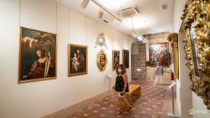
Institute of Modern Art
The Instituto Valenciano de Arte Moderno (IVAM) is a modern and contemporary art museum with a permanent collection of about 12,000 works by both Spanish and international artists.

The building also hosts temporary exhibitions, conferences and cultural or artistic events. At the IVAM you can learn and reflect on the ideas and styles that have shaped artistic discourses from the beginning of the 20th century up until now.
The IVAM is at the northwestern edge of the neighbourhood, just where Carrer de na Jordana meets Carrer de Guillem de Castro (view map above).

Centre del Carme Cultura Contemporània
Centre del Carme (also known as CCCC) is a contemporary culture centre that hosts a wide range of artistic practices representative of current culture.

Among these, you will find visual arts, experimental and performing arts, sound art and design, as well as other branches of thought such as sociology, architecture, urban planning, and medicine.
The centre occupies part of what used to be a 13th-century monastery, the Real Monasterio de Nuestra Señora del Carmen. In fact, it was this monastery to give its name to the Carmen neighbourhood. The other part of the old monastery is today known as Iglesia de la Santa Cruz.

The CCCC is in the eastern section of the Carmen neighbourhood, not far from the Serranos Towers (view map above).
Ethnology Museum
The Museu Valencià d’Etnologia is an ethnology and anthropology museum. Founded after the fall of Franco’s dictatorship, it is devoted to collecting and researching Valencian traditional and popular heritage.
This cultural institution aims to question and investigate the different aspects of Valencian culture and the dynamics that built and developed it, including its interaction with other Mediterranean cultures.

The Museum is located in the Beneficència Cultural Centre, in the western part of the Carmen neighbourhood (view map above).
Museu de Prehistòria
The Prehistory Museum, particularly appreciated by children, displays and researches archaeological materials spanning from the Paleolithic to the Visigoths periods. The Museum features permanent exhibitions, temporary exhibitions, restoration workshops, a library, and a teaching department.

The Museum, just like the Ethnology Museum, is also located in the Beneficència Cultural Centre, in the western area of the Carmen neighbourhood (view map).
Casa-Museo José Benlliure
This studio house turned museum will immerse you in the life and works of local painter José Benlliure. You will walk into a permanent exhibition centre, displaying not only the works of the artist but also his home and workshop.

The House Museum offers a unique portrait of turn-of-the-century-Valencia and how wealthy families in the city lived at the time. It is located at the northern edge of the neighbourhood, not too far from the Serranos Towers (view map above).

The Streets
In El Carme, it’s not just the churches, ancient buildings and museums that reveal Valencia’s past. This neighbourhood tingles with the thousands of stories that have taken place in its alleys, told in its squares, and woven into its walls.
.
Street Art
While many buildings in Valencia display beautiful and elaborate artworks, the highest concentration of murals is in El Carme. Here, you can find amazing works of art that create unusual and striking sights, standing in contrast with their canvases, the walls of this barrio.
You’ll find art everywhere: on the old and crumbled walls, on the low ones in the unassuming and narrow streets, and on the large ones right next to important sights. Here urban art is abundant, and artists continuously put their talent to work, making this neighbourhood an open-air museum.

The temporary nature of this art form means that the murals are often replaced by the very active street art community, transforming the neighbourhood overnight. Locals appreciate the contribution that the pieces make to the city, commenting on society, politics, and local culture. This allows for the artists to work mostly undisturbed, even though graffitis are not officially permitted.

As you’re walking in the centre, make sure to walk down the smaller streets and alleys. You never know where you might find pieces of art or even the artists themselves at work.
Plaza del Árbol
Where Calle Baja and Calle Santo Tomás converge (view map above) you’ll find a small square known as Plaza del Árbol (Tree Square). Although the olive tree you will find here is less than 100 years old, documents attest that the square has had a tree in it for more than 300 years.

The square is today the location of a bar, making it a meeting point for many in lively Valencia.
If you’d like to know more about the square, you can check out our article about it.
Plaza del Tossal
Plaza del Tossal, between El Carmen and El Mercat, is one of the places in Valencia where you can enjoy the laid-back and upbeat soul of the city (view map above).
This square, full of life, people, charming shops and bars, is one of the most appreciated spots for leisure and going out with friends. You can take a stroll around and choose from the numerous options in Plaza del Tossal. You’ll find plenty of places to drink, spend your evening, and dine.

Underneath all this, is a part of Valencian history. Galería del Tossal is an underground gallery and exhibition centre. There, you’ll see the remains of a tower and a stretch of the 12th-century Islamic wall.
If you’d like to know more about the square, you can check out our article about it.
Plaza del Negrito
The Plaza del Negrito is the square of bohemians. When the sun is still high, you can enjoy a quiet afternoon in the square, with the relaxing gurgling and gentle splashing of the fountain. At night, the square becomes alive with bars and drinking.

The name of the place dates back to the 1850s when drinking water was brought to the city through numerous fountains.
One of the most important ones was installed here and adorned with a statue of a chubby boy standing over a bowl. The sculpture was made of dark metal, so people started calling it Plaza del Negrito.

Plaza del Negrito is also between two neighbourhoods (El Carmen and La Seu). It isn’t far from the Cathedral of Valencia (view map above).
If you’d like to know more about the square, you can check out our article about it.
Mercat Mossén Sorell
This small and charming boutique market is one of the most modern ones in the city. Initially put up in 1932, it was recently (2008) rebuilt.
The harmonious concrete and iron structure and its large glass windows are perfectly nestled among the nearby houses and buildings of El Carmen. Mercat Mossén Sorell is a popular spot to drink and dine, savouring local wines, products, and tapas.

This market is in the heart of El Carmen, not far from Plaza del Tossal (view map above).
If you’d like to know more about this market, you can check out our article about it.
Casa de los Gatos
Casa de los Gatos, also known as La Gatera (Cat House) is a miniature house in Calle del Museo (view map above).
It consists of a three-story house façade painted in full detail on a street wall, a home for the cats of El Carmen.
The miniature looks like a perfect reproduction of a regular Valencian house: windows, balcony, tiled roof, water fountain, courtyard door, fire insurance plaque, and of course an entrance door with steps. This door, complete with a heraldic coat of arms, serves as an actual entrance for the local cats, which reside in the adjacent garden.

Above the fountain, next to the fire insurance plaque, you will also notice another ceramic panel, which reveals the origin and inspiration behind this piece. The inscription reads “In memory of the four cats that were left in Barrio del Carmen in 1094”. This refers to a popular story relating to Cid Campeador, a Catholic leader who conquered Valencia that year.
When El Cid entered the city, he found as many cats as there were citizens. He deemed that the animals were diabolical creatures and bearers of bad luck, so he ordered the execution of all cats in the city.

According to tradition, only four remained in the whole of Valencia after the event. It is these four cats that the Casa de los Gatos’ artist Alfonso Yuste Navarro honours with his sculpture.
The Turia Park
This is the serpentine urban garden, known as Jardín del Turia. Although not part of the neighbourhood proper, it hugs the northern part of El Carmen.
The park is almost 10 km long (about 6 miles) and provides a much-needed green space in the city. In it, you can find leisure areas, fountains, footpaths, bike lanes, open-air gyms, and sports pitches (including football and baseball).

The garden is divided into 16 sections (tramos in Spanish), separated by various bridges that help pedestrians and vehicles alike cross to the other side. If you would like to know more about this park, you can check out our article about the Jardín del Turia.
Nightlife
Aside from its culture and history, El Carmen is known also for its vibrant and diverse nightlife. In this neighbourhood, you’ll find anything from rock music venues, jazz clubs, live performances, modern disco clubs, and vintage or bohemian bars.
Here we focus specifically on the nightlife in El Carmen. If you’d like to know more about Valencian nightlife in general, you can check our Nightlife section.
Here you have the most well-known and lively spots in El Carmen.
Plaza del Tossal
This square is one of the most appreciated and busiest spots for leisure and going out with friends. Plaza del Tossal is located between two neighbourhoods, El Carmen and El Mercat (view map above).
Overlooking the Plaza you’ll find five cocktail bars, three restaurants, as well as a kebab place. If you go down the adjacent streets (Plaça de Sant Jaume, Carrer dels Cavallers and Carrer de la Bosseria) you’ll find even more options.
If you’d like to know more about the square and its nightlife, you can check out our article about it.
Plaza del Negrito
When the sun is still high, you can enjoy a quiet afternoon in the square, but in the late evening and at night, the square transforms, becoming a perfect little corner to enjoy local drinks such as Agua de Valencia.
Plaza del Negrito is located between El Carmen and La Seu (view map above).
In the square, you’ll find three bars and two food venues, but of course, there are many more in the nearby streets (Carrer de Calatrava and Carrer dels Catalans).
If you’d like to know more about the square and its nightlife, you can check out our article about it.
Location and Transportions
El Carmen is a part of the historical centre, the Ciutat Vella district. Because of its location, it is well connected to public transport and easy to navigate on foot or on a bike.
Location
El Carme is the northernmost area of the Ciutat Vella district, Valencia’s Old Town. It is delimited by Carrer de Quart to the south, Carrer Guillem de Castro to the west, and Turia Park to the north.
Transportation
Due to the barrio’s small size and pedestrian streets, the best way to move around the neighbourhoods is on foot or by bike, if you prefer.
On foot
To reach El Carmen we suggest walking, as long as you are near the Old Town. If you are in the outskirts of the city or in the peripheral districts, you might need to take some kind of public transport.
Once you’re inside theCarmen it’s much easier and more convenient to walk than anything else, so you can experience the neighbourhood to its fullest.
Bikes
Whether you are in the Old Town or in the outskirts of the city or in the peripheral districts, you can cycle to reach your destination, as Valencia has an extended bike path network.
Biking is also one of the preferred forms of transport for people to move around the city centre.
There are several Valenbisi stations in El Carmen and nearby, you can consult them on the official map.
Buses
There aren’t buses circulating within the barrio itself. Nevertheless, you’ll find that buses stop along the entire perimeter of the Old Town, for example right in front of the Serranos Towers or the Quart Towers. Buses C1, 28, and 95 are the most frequent ones to follow that route.
For detailed information about tickets and how to get them, you can read our article about buses in Valencia.
Metro and Tram
There are no metro stops in the neighbourhood, but the closest ones are Àngel Guimerà and Túria (to the west) and Xàtiva andColón to the south. These metro stops are all 10-15 minutes away from El Carme.
The tram network is mostly located north of El Carme. The closest stop is Pont de Fusta, just 500 m (0.3 miles) away from Torres de Serranos.
For detailed information about how this system works, you can read our article about the metro and trams in Valencia.
Electric Scooters
Electric scooters are a good way to get close to El Carmen if you are in the peripheral neighbourhoods of the city. They allow you to move independently, quickly, and without getting stuck in traffic.
However, keep in mind that you cannot use them or park them inside the Old Town, where the El Carme is. This means you will need to park your scooter just outside the no-park zone, which you will see on your app’s map.
Scooter-sharing companies offer rental plans that let you pay per minute of use and nothing else. If you want to know more about this, you can check out our article about electric scooter rentals in Valencia, where you’ll find step-by-step instructions and video guides to help you.
Taxi
Cabs are obviously the most expensive option to move in Valencia. Considering El Carme’s central position and its narrow, one-way streets, we recommend you only use taxis when strictly necessary (for example maybe late at night).
See detailed information on this in our article about taxis in Valencia.
Nearby Areas
Being part of the Old Town, El Carmen is also close to other famous neighbourhoods in the district, namely La Seu and El Mercat. Some of the most well-known sites in Valencia are found here.
For example, the Central Market and the Lonja de la Seda are right in front of each other in the El Mercat neighbourhood.
In Barrio de la Seu, you will find Plaza de la Virgen and the Cathedral of Valencia, the city’s most important religious building (it is home to the Holy Chalice), with its bell tower Miguelete.
The lesser-known El Pilar neighbourhood also borders El Carmen in its southwestern section. There, you will find the Col·legi de l’Art Major de la Seda, a museum devoted to silk and silk production.
If you want to have a look at the Old Town district as a whole, you can check out our article on it.
Frequently Asked Questions
Here you can find quick answers to all of your questions. Linked, you’ll find the articles or the sections of the articles that can give you more detailed information.
-
Barrio del Carmen is a neighbourhood in Ciutat Vella, Valencia’s Old Town district. It is a must for anyone interested in sightseeing.
-
Although they often used as interchangeable terms, El Carmen and the Old Town (also called Ciutat Vella) are not the same thing.
Ciutat Vella is a district in Valencia, formed by six neighbourhoods. One of those neighbourhoods is El Carmen.
-
El Carmen is a vibrant area, known for its mediaeval remains, century-old streets and houses, museums, street art, nightlife, and artisanal businesses.
-
El Carmen is in the northwestern part of the city centre. It is delimited by Carrer de Quart to the south, Carrer Guillem de Castro to the west, and Turia Park to the north.
-
In El Carme, you can find various churches, but the most famous ones are the Saint Nicholas Church andSanta Cruz Church, also known asIglesia del Carmen.
-
The neighbourhood is known for its many museums. Some are devoted to documenting the ancient history of the city, like the Ethnology Museum, theMuseu de Prehistòria, and theCasa-Museo José Benlliure.
Some others, like the Institute of Modern Art andCentre del Carme Cultura Contemporània, are dedicated to the preservation and investigation of the contemporary and avant-garde forms of art practised in Valencia.
-
El Carmen is extremely rich in monuments and sights. The most important historical monuments are the Torres de Quart, the Torres de Serranos, the remains of the Muralla Arabe, and thePortal Valldigna.
Other famous sites in the neighbourhood are Casa de los Gatos,Plaza del Arbol,Plaza del Tossal,Plaza del Negrito.
-
El Carmen has plenty of food options, with traditional restaurants and tapas bars all over the centre. A great spot for local food and drinks is the Mercat Mossén Sorell. You can find out more about it in the relevant section of this article.
Remember that here you can also find international restaurants and bakeries or chic and modern breakfast spots.
-
The most famous squares for drinks and music in El Carmen are Plaza del Tossal and Plaza del Negrito.
-
El Carmen is quite small but extremely rich in sights, so it is best explored on foot, or if you prefer, on a bike.
-
Valencia is an extremely bike friendly city. On the official map, you’ll see that the bike paths are all around the city’s old quarters. You can also cycle inside El Carmen itself and its pedestrian zones, as long as there is enough room for people to walk.
-
While there are no buses circulating in El Carmen, there are quite a few ones that drop you off nearby, like lines C1, 28, and 95.
The bus stops with the most lines are in front of the Serranos Towers and the Quart Towers. For detailed information about this, you can read our article about buses in Valencia.
-
There are no metro stops in El Carmen, but the closest ones are Àngel Guimerà, Túria, Xàtiva, and Colón. These metro stops are all 10-15 minutes away from this barrio.
-
The tram network is mostly located north of El Carme. The closest stop is Pont de Fusta, just across the bridge from the Serranos Towers.
-
There are five Valenbisi stations all over El Carmen and many more in the surrounding neighbourhoods of the Old Town.
-
Generally no. If you have a rented electric scooter, you cannot park in some sections of the Old Town, where the El Carme is. You will need to park your vehicle just outside the no-park zone, which you will see on your app’s map.