At the edge of Valencia’s Old Town stands a Neoclassical temple of dust, sweat, and blood. This 19th-century bullring is home to one of the most controversial Spanish practices.
Plaza de Toros in a nutshell…
Valencia’s bullring is an impressive 19th-century Neoclassical amphitheater where traditional Spanish bullfights are still held, offering both regular tours and controversial bullfighting events during festival seasons.
Location: At the southeastern edge of Valencia’s Old Town, immediately east of Estación del Norte and at the boundary between the historic center and newer neighborhoods like Eixample.
Transportation: Extremely accessible via metro (Xàtiva station directly next to it), tram (Alacant stop), numerous bus lines stopping at Estació del Nord, Valenbisi bike stations directly in front, or walking from most central locations.
Tickets: Regular visit tickets (museum and arena) range from €2.00-€6.50; bullfighting event tickets range from €15.00-€40.00 depending on seat location and event type.
Visiting hours: Open for museum and arena visits Monday to Saturday 10:00am-7:00pm and Sunday 10:00am-2:00pm; bullfighting events primarily held during March (Fallas), May, July, and October.
The Plaza de Toros, also called Plaça de Bous (in Valencian) is the city’s bullring. It is considered by many one of the most important in Spain, where bullfights are regularly held up to this day.
Bullfighting is an extremely ancient tradition in Valencia, even though the ring was built in the 1800s. In fact, for centuries before then, bullfighting events would take place in empty squares all over the city and in temporary wooden bullrings.
With the growing popularity of the city and the celebrations, it was deemed necessary to build a permanent venue to host the events.
The style of the building, of course, is very indicative of the era in which it was built. As you’ll see, the bullring is strongly reminiscent of ancient Roman and Greek art, in keeping with the Neoclassical taste of the time. The lines are simple and clean, quite harmonious, and with minimal decoration.
Northleg
/
copyright
Valencia’s Plaza de Toros is a stunning 19th-century bullring that offers a glimpse into Spain’s rich architectural and historical heritage.
Bullfighting is one of the most popular elements of Spanish culture on an international level. At the same time, it is also one of the most controversial.
Some consider it a viscerally significant part of Spanish tradition. For them, it is a ritualised art form in which the public is led to emotional catharsis by a noble display of bravery - both on the part of the bullfighter and the bull - and by the tragic, inevitable ending - the death of the animal.
Others instead, especially among the younger generations, where bullfighting is actively disliked, consider it an inhumane and unnecessarily cruel practice.
If you want to experience the trepidation and excitement of a bullfight in a Spanish bullring, remember that the most important events are held in March, during the Fallas festival and during the July Fair.
Otherwise, if you prefer not to attend such events, the bullring remains open year-round for tourist visits. Plaza de Toros is lodged between Valencia’s old quarters and the newer neighbourhoods, right next to the main train station, Estación del Norte.
Tickets
In terms of tickets, remember that you can either get a ticket for a regular visit or a ticket for a live bullfighting event. The visit includes access to the museum and stadium and should take about one hour. The bullfight on the other hand can last several hours.
Northleg
/
copyright
The Museo Taurino in Valencia offers visitors a deep dive into bullfighting history, with flexible visiting hours and affordable entry prices for those curious about this traditional Spanish cultural practice.
Please note that around the time of a bullfighting event (before and after), you’ll still be able to visit the museum, but you won’t be able to access the arena.
Here you have a summary table of the regular entry (including access to the museum and stadium) prices.
Day
Price
Day
Regular
Reduced*
Saturdays/Sundays/Holidays
Price
€2.00
€1.00
Free
Children under 7, school groups with a professor, teachers, the unemployed, and local tour guides always enter for free.
On 18th May (Museum Day in Spain), everyone enters for free.
*Reduced fares apply to students, retirees, groups of 10 or more, and large families.
The price of the tickets for the corridas depends on the type of event and the seat you choose, much like in a football match. Prices oscillate between €15.00 and €40.00.
You can either get those tickets online or directly at the Bullring. If you want to get a suggestion on where to sit to get the best view, we recommend you get your tickets directly there.
Opening Hours
You can obviously enjoy the outside view of the Plaza de Toros at any time in Valencia, but to go see the inside, the stadium and museum, or even the corridas, there are opening times.
Here we have put together a table with the opening times for a visit to the museum and arena.
Day
Opening Times*
Day
Mondays
Tuesday - Saturday
Sundays & Holidays
Opening Times*
Closed
10:00 am - 7:00 pm
10:00 am - 2:00 pm
The Bullring is also closed on 1st January, 1st May, 25th December.
*Last access to the museum is half an hour before closing time. Last access to the arena is generally 45 minutes before closing time. In the winter it is at 5:30 pm (because of the sunlight).
As for the bullfighting events, they generally take place around specific times of the year. These periods of activity are the Fallas festival (1st-19th March), the Virgen de los Desamparados festivities (second Sunday in May), the Feria de Julio (in July), and the Feria de Octubre (on 9th October).
Location
Valencia’s Plaça de Bous is located just outside Valencia’s old city walls.
It is immediately east of the city’s main train station, Estación del Norte, where the Old Town (to the north of the Bullring) meets the newer neighbourhoods (to the south), like the Eixample.
The stadium is enclosed by Calle de Xàtiva to the north (the street that passes in front of the train and metro station), Carrer d’Alacant to the west, and Calle de Castelló to the south.
How to Get There
As the Bullring stands on the line between the old quarters and other neighbourhoods of the city, chances are you will pass by it or have already done so, whether you are walking or taking a bike.
If you are in a different part of the city, you might want to take public transport.
By Metro or Tram
The Plaça de Bous is in a great position to be reached by metro and tram, as there are various stops nearby. Depending on where you are located, one or the other might be more convenient.
The closest stations are:
Xàtiva: metro stop just next to the Bullring, directly in front of the main train station.
Colón: metro stop northeast of the Bullring.
Alacant: tram stop right between the train station and the Bullring.
Xàtiva is only 1 minute away from the Bullring, while Colón is 600 m away (7-minute walk, a little under 0.4 miles) from it. The same three lines (3, 5, 9) stop at both stations.
The tram network’s line 10 stop, Alacant, is to the side of the building.
By Bus
The Bullring is close to both Estación del Norte and Plaza del Ayuntamiento, both key points in the urban bus network, so there are are quite a few buses stopping right by it.
The closest bus stop is probably Estació del Nord, directly in front of the Bullring. To reach the entrance from the bus stop you’ll only need to walk about 1 minute (50 m, 164 feet).
The other stop is Xàtiva, a little down the street to the west, but still very close (200 m, about 0.1 mile). You’ll find other stops all around the train station area, but these two are the ones with the most lines.
Line
Stop
Line
C1
6
7
8
11
19
28
35
40
70
71
73
Stop
Xàtiva
Estació del Nord
Xàtiva
Estació del Nord
Xàtiva
Estació del Nord
Xàtiva
Estació del Nord
Estació del Nord
Xàtiva
Xàtiva
Xàtiva
By Taxi
Cabs are obviously the most expensive option to move around the city, and they might not always be the most comfortable way to get to your destination.
As the Plaça de Bous is so well connected, we would recommend this means of transport if your departure point is not close to any form of public transport, maybe in the outskirts of the city.
In any case, it is normally quite easy to hail a taxi in the street in Valencia, but other options are also booking through a mobile app or through a phone call..
By Bike
Valencia is a very bike-friendly city, so we always recommend exploring it this way.
On the official map, you’ll see that there are bike paths circling the city’s old quarters. You can also cycle in the city centre and its pedestrian zones, as long as there is enough room for people to walk.
On the same map, you will also see that there are two Valenbisi stations by the Bullring. One is right in front of it, the other one is a little further down the street, in front of the train station. Many other Valenbisi stations are also not far away.
By Scooter
Electric scooters are an ever-more popular transport solution in Valencia. They are ideal if you want to move independently around the city and you don’t want to get stuck in traffic, but you don’t like cycling or walking. Many scooter-sharing companies offer rental plans that let you pay per minute of use and nothing else.
You can park and drive your scooter within a designated area in the city’s urban zone. Generally, you are not allowed to park throughout most of the old quarters of the city. Luckily for you, the Bullring is just outside that no-park zone, so you’ll be able to park your scooter just by it.
On Foot
Given that Plaza de Toros is in such a visible spot, it is normal that reaching it on foot is not difficult at all, so if you are in the Old Town, going on foot is the easiest option. In fact, it is likely that you will pass by it when going from the older historical quarters of the city to the newer ones, like the Eixample.
From Plaza del Ayuntamiento, located in the old quarters of the city, you’ll only have to walk 300 m (4-minute walk, a little under 0.2 mile). To reach your destination, simply walk along Avenida del Marqués de Sotelo.
The Serranos towers, at the opposite end of the centre (the northern edge), are 1.5 km (about 0.9 miles) away. You could, for example, take a short walk (about 18 minutes) and cross the entire city centre to go from one point to the other.
Useful Tips for Your Visit
Here you have our recommendations and tips to ensure that you make the most of your experience at Valencia’s Bullring.
Bullfighting events in Spain have only been forbidden in some cities or regions (most famously Catalonia, the Canary Islands, and the Balearic Islands don’t host them). This means that bullfighting events still take place in other parts of Spain, Valencia included.
It is also worth taking note that in bullfighting events, the bulls are always killed in front of the audience (several bulls per event). If you oppose such traditions or are sensitive to violence, we strongly advise you to avoid the bullfighting itself. You can still visit the venue and its museums when there is no bullfighting.
On the same note, during the museum visit, you might want to avoid the video where they show the killing of a bull in detail, as you might find it uncomfortable and disturbing.
If you are going for a regular visit (as opposed to a scheduled bullfight), you might find the arena closed, thus you’ll only be able to visit the museum. This is likely because the space needs to be prepared for the corridas or cleaned up after a show. To avoid this, make sure not to visit the Bullring immediately before or after a bullfighting event.
The steps in the seating area of the stadium are quite steep and climbing them might take some energy, so we recommend you always have water with you.
If you do decide to attend a bullfighting event, remember there is one side of the stadium in the sun and another one in the shade. The seats in the shady part are generally more expensive, but it is worth the investment, especially if the weather is hot that day.
Curiosities
In this section you can find out more about the divisive bullfighting tradition, its different events, as well as how to tell if there’s an event going on inside the Plaza de Toros.
The Flags
If you’re ever wondering whether there’s an ongoing event in Valencia’s bullring, there are a few ways to find out. Of course, you can just ask someone or look it up on the internet, but there is a much more immediate way to do it. That is if you know what to look for. All you have to do is look at the flags at the top of the Plaça de Bous.
If you see all the flags on their masts, there is a corridade toros going on (with fully grown bulls, which weigh more than 500 kg, around 1,100 pounds).
If there are flags only on every other flagpole, it is a novillada (a bullfight where the bullfighter has not officially become a matador and the bull is still young, between two and three years of age). If there are flags on every third flagpole, it is a becerrada (a bullfight with a very young bull, no older than two, and non-professional participants).
Types of Bullfighting
Bullfighting is a tradition practised in various countries, most notably in Spain. However, there is more than one type of bullfighting style and certainly more than one bull-related type of activity in Spain.
Corrida de Toros
The event you’ll probably think about when hearing the word is what in Spain is known as corrida de toros (or simply corrida). This is highly standardised performative art, with distinct phases and participants, each playing a well-defined role.
Northleg
/
copyright
Valencia’s historic Plaza de Toros still showcases the enduring tradition of bullfighting.
In each of the three parts of the event, which takes place inside a bullring, the toreros (trained bullfighters) follow a practised routine. A set of norms, rules, and traditions must be respected. At the end of the third act, the bull is killed among the applause and cheering of the audience.
Novillada and Becerrada
These other two events, unlike the others that we will see in the next paragraphs, are still practised in a bullring. To varying degrees, they can also be similar to regular corrida.
The novillada is still highly standardised and regulated, as the matador, although not officially registered, is still a trained professional. The bull, however, is younger and thus smaller than in a regular corrida.
The becerrada, on the other hand, only uses extremely young bulls, generally less than two years old. This is an event where even non-professionals can take part (and they often do).
Encierro
Another event you might have heard of is the encierro, the running of the bulls. This is a tradition that usually takes place during summertime festivals, where a part of the town is sectioned-off and a group of bulls are let loose together with tens of volunteer runners.
The run usually ends with the bulls entering the bullring, where they will later participate in a corrida. The most well-known of these events is the San Fermín Festival, in Pamplona. In the city of Valencia there is no such event, but there are corridas taking place in the Plaza de Toros.
Recortes and Toro Embolado
Other events still are recortes, a much less stylised and standardised practice than the corrida, where men perform acrobatic bull-leaping inside the arena, and toro embolado (bull with balls, in English).
The latter is very similar to the encierro, except that it is celebrated at night, and the bulls that are set free in the streets have flammable material attached to their horns.
Bullfighters
Bullfighting is certainly one of the most controversial performances in Spain. For supporters of animal rights, it is a cruel and barbaric tradition, where an unknowing animal is tortured and killed for the enjoyment of a crowd.
But for the aficionados, it is a feverishly admired tradition, an elevated art form. In older times, the passion aroused by bullfighting events was so great that it could be compared to modern-day big-scale football events.
Northleg
/
copyright
Right outside the plaza you can find a statue of Valencian bullfighter Manolo Montoliu, who tragically died in Seville’s bullring. The bronze memorial was created in 1992.
The bullfighters, and especially the matadors (the ones who will kill the bull), have always been highly regarded figures in Spanish tradition, to the point of being considered celebrities. Stories are told of how people would even pawn their clothes to be able to see acclaimed bullfighters, such as Frascuelo.
Nowadays, if a little less popular, these figures are still highly regarded. In fact, in Valencia, you’ll find that fans and institutions have wanted to pay tribute to their idols through statues in the likeness of the bullfighters who died in the ring.
The bronze statue that you can see by Valencia’s bullring ticket office is in honour of Manolo Montoliu, regarded as one of the best bullfighters in history.
Brief history
Although the Plaza de Toros itself is a relatively modern building, built in the mid-1800s, bullfighting is a long-standing and much more ancient tradition.
Northleg
/
copyright
The historic Plaza de Toros, originally a wooden structure and rebuilt in 1850, stands as a stunning architectural landmark in the heart of Valencia.
According to some historians, bull-related celebrations were already practised in Neolithic Turkey (as early as 3000 BC), while the bullfight itself can be traced back to Roman gladiator games (1st century BC).
Written Mention in Valencia (1373)
The first written references to bullfighting events in Valencia date back to 1373, in the Manual de Consells (a sort of Council Registry). After that, numerous other written references were made.
This doesn’t mean that Valencia didn’t host bullfighting events before that, rather that there is no certain date as to when the first celebration was held. Supposedly, the tradition in Spain dates back to 711 AD.
Bullfights Held in Public Squares (1300-1800)
Initially, bullfighting spectacles were held in different parts of the city, wherever there was enough open space. A popular location was the Market Square, where the Central Market is now located.
With time, temporary structures began to be erected for the occasion. These constructions, which were dismantled right at the end of the celebration, became known as Plazas de Toros (Bullrings) over time.
Valencia’s General Hospital Sponsorship (1625)
Valencia’s hospital started sponsoring the festivities (and the construction of temporary structures) to finance the hospital’s financial needs through the income generated by the event.
Permanent Wooden Bullring (1788)
Given the great popularity of the event, the decision was made to build a permanent bullring. A wooden structure was built on the site of the current Plaza de Toros (then land owned by the General Hospital).
Demolition (1808)
Valencians demolished the wooden Plaza de Toros to prevent the French from gaining a foothold there during the Peninsular War (1807-1814). After the demolition, the bullfights returned to the squares, outside the city walls.
Construction of the Current Bullring (1850-1851)
The then governor of Valencia did not consider it safe for the festivities to be held in the streets, so he promoted the construction of a new bullring. The construction had to be stopped for financial reasons in 1851, after only three floors had been built.
Construction Continues (1857)
The project was finished with the remaining tiers built in brick.
First Bullfight (1859)
The first bullfight in the new ring took place even before the official inauguration of the building.
Inauguration (1861)
The official inauguration took place in 1861. At the time, the building had a capacity of 16 800 spectators.
Museum (1929)
The Bullfighting Museum, still existing today, was founded.
Prison (1939)
At the end of the Civil War (1936-1939), the building was temporarily used as a prison and concentration camp for Republicans by Franco’s dictatorship.
Renovations (1967)
The wooden stands were replaced with concrete, the ticket office was built, and barriers were installed.
National Monument (1983)
Valencia’s Plaza de Toros was declared a National Artistic Monument.
Capacity Reduced (1995)
Due to safety requirements, the number of seats was reduced to around 12,000.
Architectural elements and style
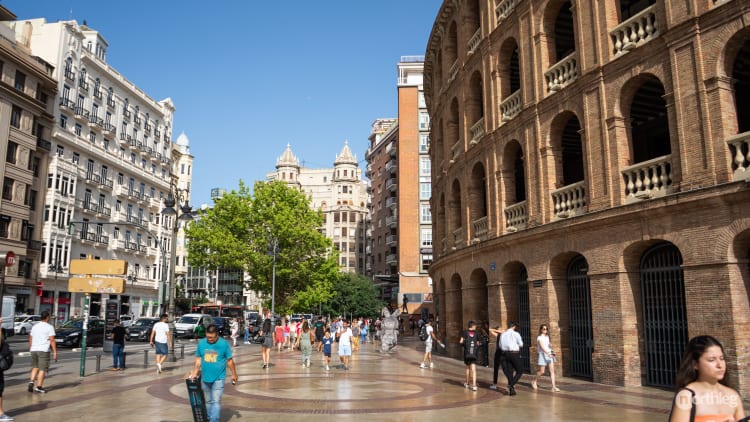
The Plaça de Bous is one of the most important visual landmarks of the city, despite the urban planning of its surroundings, which tend to cover it up and make it hard to appreciate the bullring’s true scale.
Style
As you will immediately notice, the Plaza de Toros is an amphitheatre reminiscent of the Roman Coliseum, although much smaller. With its simple arches and exposed brick, it can be classified as Neoclassical.
Neoclassical architecture, which rose to popularity in the 18th century, drew inspiration from the art and canons of classical antiquity and continued to be popular in the 19th and 20th centuries. The style was based on the principles of harmony and symmetry, seen as virtues of Ancient Roman and Greek art.
Thus, in Neoclassical architecture like the Plaza de Toros you’ll find simple geometry and moderation. You’ll see this particularly in the use of ornamentation, which is very restrained, with only a few mouldings.
You’ll also notice that most of the aesthetic character of the building comes from the repetition and symmetry of the elements - the arches, the columns, the balustrades, and the brick.
Elements
The building is in the shape of a cylinder formed by orders of porticoed galleries rising above one another. Although the bullring looks circular, it is actually a 48-sided polygon, with every arch forming one of the sides.
The total height is 16.9 m (55 feet), with an outer diameter of 108 m (354 feet). The inner diameter, that of the arena, is 52 m (170 feet). There are a total of 384 arches that open up the porticoes to the exterior, distributed over four orders.
The ground floor presents segmental arches (a broad type of arch with a slight curvature at the top). Meanwhile, the three upper floors have semicircular arches (the classic arch where the top part forms a semicircle). Crowning the whole building is a stone balustrade.
Inside, supporting the grandstand, you’ll find bare iron railings. This, aside from being the first example in the city of such use of the material, gives great transparency to the area, allowing for a perfect view of the arena.
Frequently Asked Questions
Here you can find quick answers to all of your questions. Linked, you’ll find the articles or the sections of the articles that can give you more detailed information.
Plaza de Toros, also known as Plaça de Bous, is Valencia’s bullring.
Yes, Valencia’s Plaza de Toros is still active to this day. This means that bullfights are regularly hosted and celebrated in the bullring.
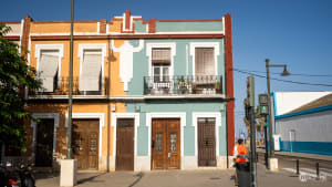
Plaza de Toros is at the northern edge of the Ruzafa neighbourhood, near the southern section of the Ciutat Vella district.
Bullfights (corridas) generally take place around specific times of the year. These periods of activity are the Fallas festival (1st-19th March), the Virgen de los Desamparados festivities (second Sunday in May), the Feria de Julio (in July), and the Feria de Octubre (on 9th October).
Yes, when you enter the Plaza de Toros you can visit both the arena where the bullfights are held, and the Museo Taurino. In the museum, you can find out more about the bullfighting traditions in Spain and about this arena in particular.
Plaza de Toros is an amphitheatre reminiscent of the Roman Coliseum and as such, it can be easily classified as Neoclassical.
The current Plaza de Toros was built between 1850 and 1857, although a wooden bullring had been built on the site in 1788.
If you are in Ciutat Vella, the best way to reach Valencia’s Plaza de Toros is probably to go on foot, or if you prefer, on a bike.
If you are further away and need to use public transport, you can easily reach the square by metro, tram, or bus.
It depends on whether you just want to visit the arena and museum, or if you go to see a bullfight.
Normally, a regular entrance ticket to the arena and museum costs €2.00.
The price for a seat at the corrida costs between €15.00 and €40.00. For more information on discounts and free entrances, you can check them out in the relevant section of this article.
Of course you can. Valencia is an extremely bike friendly city, and on the official map, you’ll see that there are bike paths circling the city’s old quarters. You can also cycle in the city centre and its pedestrian zones, as long as there is enough room for people to walk.
The Plaza de Toros is near the main train station, so there are a lot of buses that stop nearby. Buses C1, 6, 7, 8, 11, 19, 28, 35, 40, 70, 71, and 73 all stop in front of the Plaza de Toros.
The metro is one of the best public transport methods to reach the bullring. Lines 3, 5, and 9 all stop at the closest metro station, Xàtiva.
The tram is also a good way to get to Plaza de Toros. Line 10’s stop Alacant is to the side of the bullring.
Of course. There are two Valenbisi stations in front of Plaza de Toros, and many others not too far away.
Yes. But be careful not to go into the no-park zone, which roughly covers the Old Town area.
You can see where you’re allowed to park on your app’s map.
Nearby Places of Interest
Being between Valencia’s old quarters and the newer neighbourhoods, the Plaza de Toros is rather close to many of Valencia’s landmarks and important buildings.
Plaza del Ayuntamiento
Plaza del Ayuntamiento or Plaça de l’Ajuntament in Valencian, is the City Hall square in Valencia. As such, it is one of the most important and central squares of the city. Every day, locals can be found relaxing by its fountain and enjoying the view of its flower market.
The Plaça de Bous is only 300 m away south of the Town Hall Square (4-minute walk, less than 0.2 miles).
Mercat de Colón
The Mercat de Colón is one of the most beautiful buildings in Valencia and one of the most important examples of Valencian art nouveau.
In the past, the site had been a market like many of the others that can be found in the city, but today it is more of a dining and drinking venue, with fine restaurants, bars and outdoor cafés. Now renovated, this gated centre is decorated with ceramic details and sheltered by brick columns and a wrought-iron roof.
The Mercat is only 800 m east (10-minute walk, 0.5 miles) of the Plaza de Toros.
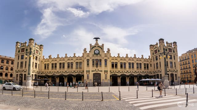
Estación del Norte
Estación del Norte or Estació del Nord in Valencian, is Valencia’s main railway station. Designed by architect Demetrio Ribes and completed in 1917, it’s considered one of the city’s most beautiful examples of modernist architecture, featuring intricate ceramic mosaics and decorative elements that celebrate Valencia’s cultural heritage.
The station is conveniently located just next to the Plaza de Toros (2-minute walk).


 Northleg
/
copyright
Northleg
/
copyright